Space laser spies for woodpeckers
- Published

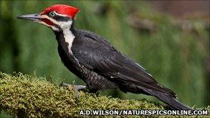
Pileated woodpeckers sport spectacular red crests
US scientists are developing techniques to monitor woodpeckers from space.
An Idaho University team has been using a satellite-borne laser to try to predict in which part of a State forest the birds might be living.
The instrument cannot see individual woodpeckers or trees, but it can determine the key characteristics of a woodland, like how dense it is.
Initial work has shown maps built from such data can locate areas favoured by North American pileated woodpeckers.
The scientists want to know where these birds are because they are seen as good indicators of overall bird diversity in a forest.
"They create homes for lots of other species in the forest setting," explained Dr Kerri Vierling from the university's fish and wildlife department.
"They make cavities and those cavities are then used by other species for nesting and roosting.
"Woodpeckers are very sensitive to forest characteristics, and so they're very selective about where they decide to live."
The at the American Geophysical Union (AGU) Fall Meeting, the world's largest annual gathering of Earth and planetary scientists.
The team assessed some 20,000 hectares of forest in the northern part of the state around Moscow Mountain. They used data acquired by laser altimeters flown on aircraft and on Nasa's Icesat spacecraft before its recent retirement (it was de-orbited in August).
Icesat will be replaced later this decade
Originally conceived as a means to measure the height of ice surfaces in polar regions, the Icesat instrument has also proved hugely effective in gathering information about vegetation cover in other parts of the globe.
Because of the way the beam of light sent down by the laser bounces back off canopy leaves, tree trunks and the ground, it is possible to make general statements about important forest characteristics.
Team-member Patrick Adam told 大象传媒 News: "We try to measure the diameter of the trees and their density. We can't do that directly from these instruments, but to get at diameter we can measure the height of the trees because tall trees are fatter than short trees; and we get at the density of the forest by looking at the relative amount of light that is returned from the foliage versus that which is returned from the ground.
"So by looking at the areas that have the tallest trees, we know that they also have the largest trees in diameter, and that there's a better chance of there being woodpeckers there. We don't just hypothesise that, we go out and we actually conduct ground-based woodpecker surveys in these locations as well to verify it."
Dr Lee Vierling from the university's department of forest ecology and biogeosciences added: "There's one species that needs to have high-density forest. That's the pileated woodpecker.
Pileated woodpeckers prefer a dense stand as they forage for ants
"It's a magnificent bird with a tall red crest on its head. It's a carpenter-ant foraging species so the denser the forest, the better for that particular bird."
Past survey's of forest structure have tended to be fairly labour intensive endeavours, involving sending many people into an area on foot to make the evaluation. And while such assessments produce very detailed results, they are necessarily limited in their spatial information.
Allying remotely sensed data to the ground effort should make habitat surveys more relevant over much broader areas of forest.
"If we are able to predict where woodpeckers are just based on satellite data then we can also surmise, based on some other vegetation characteristics, that we might also have higher diversity of forest songbirds or even some mammals and reptiles. That's useful in land management planning and biodiversity planning," said Mr Adam.
"It's a lot easier to use satellite data. It's important to still do some ground-truthing at a few select points just to make sure we're not totally going off tangent from reality. But in general, yes, we can cover large areas with the airborne lidar, and we're really hopeful with what we can use the space-borne lidar for because that has global coverage, so we could use that at a much larger scale."
The Icesat instrument is no longer in space, but it will be replaced later this decade. In addition, the US space agency is thinking of flying another laser instrument on its Deformation, Ecosystem Structure and Dynamics of Ice (DESDynI) mission.