
Upland limestone drainage features
A demonstration of the features formed by water drainage in limestone areas, both at the surface and underground. Permeable and impermeable layers of rock in the Malham area give rise to intermittent drainage. We see features formed both at the surface and underground. Surface water passes over impermeable rock until it reaches permeable limestone. The water passes through the limestone and erodes it to form swallow holes. Gaping Gill is a swallow hole where water has eroded a cave to form the highest waterfall in Britain. The water continues to flow underground until the limestone meets impermeable rock at the valley floor. Here there is a resurgence where the water returns to the surface. Shake holes and water sinks are also formed by the flow of surface water.
Duration:
This clip is from

More clips from Landscapes and Land Formations
-
![]()
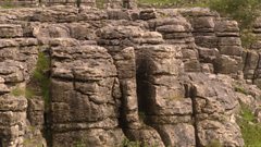
Formation of carboniferous limestone
Duration: 01:38
-
![]()
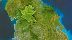
Location of Yorkshire Dales National Park
Duration: 01:09
-
![]()
Summary of upland limestone drainage features
Duration: 01:08
-
![]()
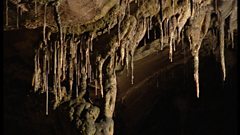
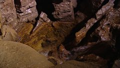
Underground features of upland limestone scenery
Duration: 02:48
More clips from Intermediate/Higher Geography
-
![]()
Malnutrition and kwashiorkor—Development and health
Duration: 02:33